


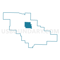
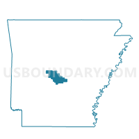
Union Voting District, Saline County, Arkansas
About
Outline

Summary
| Unique Area Identifier | 528024 |
| Name | Union Voting District |
| County | Saline County |
| State | Arkansas |
| Area (square miles) | 27.48 |
| Land Area (square miles) | 27.48 |
| Water Area (square miles) | 0.00 |
| % of Land Area | 100.00 |
| % of Water Area | 0.00 |
| Latitude of the Internal Point | 34.69835880 |
| Longtitude of the Internal Point | -92.69254230 |
Maps

Graphs
Select a template below for downloading or customizing gragh for Union Voting District, Saline County, Arkansas


Neighbors
Neighoring Voting District (by Name) Neighboring Voting District on the Map
- Beaver Voting District, Saline County, AR
- Dyer A Voting District, Saline County, AR
- Holland Voting District, Saline County, AR
- Jefferson Voting District, Saline County, AR
- Kentucky Voting District, Saline County, AR
- Salem D Voting District, Saline County, AR
Top 10 Neighboring County Subdivision (by Population) Neighboring County Subdivision on the Map
- Salem township, Saline County, AR (7,259)
- Beaver township, Saline County, AR (3,211)
- Dyer township, Saline County, AR (1,754)
- Kentucky township, Saline County, AR (861)
- Holland township, Saline County, AR (639)
- Union township, Saline County, AR (597)
- Jefferson township, Saline County, AR (263)
Top 10 Neighboring Unified School District (by Population) Neighboring Unified School District on the Map
- Pulaski County Special School District, AR (152,855)
- Bryant Public Schools, AR (46,426)
- Fountain Lake School District, AR (14,192)